Chapter 3: Great Lyakhov Island
Great Lyakhov, the most southerly one of the New Siberian Islands: its stone-ice, its frozen ground on the ice, and frozen mammoth standing upright in the frozen ground. – How does all that fit together? How has this ground-ice arisen? And why is it also covered by frozen loam and sand?
The geologist Baron Eduard von Toll: "Doctor Bunge, who has spent the summer of the year 1886 on Great Lyakhov Island, says in his preliminary report: ‘Wherever the hills are coming close to the sea, they are forming steep, vertical capes, with nice profiles, showing us clearly, how these most interesting postpliocene structures are made. They do show us, besides the layered, permanently frozen mass of loam, containing more or less sand, with the remains of animals and plants, sometimes quite colossal masses of ice, so large, as I have never seen them at the Lena and at the Yana. At one place, the vertical wall of ice measured 72´ (22 m). The ice is dull and contains many bubbles of air and earthen admixtures. ... Besides these mighty masses of ice, one finds between the horizontal layers of earth also thin horizontal layers of clear ice.
"‘During the summer, especially through the influence of the sea, these profiles are partly thawing off, moving further back into the land. With a loud splash, sometimes larger, sometimes smaller masses of earth are falling off. As a thick porridge, like a stream of lava, they are flowing then into the sea. The water, formed by the melting ice, gathered into small creeks, is rushing in deeply cut beds (toward the sea). I noticed at times at these places an intensive smell of decay or putrefaction coming from this whole mass of earth.
"´These, sometimes very imposing steep walls, one finds on the island at the southernmost part of the northwestern coast (near Cape Tolstoi), also along the whole southern coast, especially west of the mouth of the Wanykina River, and also at the northeastern coast close to Mount Kowrishka. Out of them are coming the fossil bones, also the mammoth ivory, which is making the island so attractive for the promyshlenniks (= ivory searchers). But not only bones, also the soft parts of quaternary mammals are appearing here. About one mammoth find, Baron Toll is speaking in one of his reports.
"And I myself found near bones of a mammoth, pieces of hide and hair, mixed together with earth, and hanging in tufts from the frozen wall of earth. In the bones there was still marrow, which the dogs ate; it looked chalky. These bones obviously belonged together. But they were unfortunately not in their original position anymore (they had already fallen down – perhaps the whole animal – from the slope, were covered over, and were reappearing a second time through the washing away of the sea and the warmth of the sun).’" - Toll, E. (1895: 49, 50).
Eduard von Toll then continues: "My guide told me that years ago, he had found a whole muskox... His description was very exact, even down to the color of the animal’s hair. ... The bones are usually found, when coming out of the layers of earth. Usually, they are falling down unnoticed, are covered up again, exposed again, and are moving then slowly into the sea, which at such places, for long distances, is very shallow. When there is for a long time a strong wind from the East, while sea level is low, much of the sea floor is exposed, and on it, the so-called laida of the promyshlenniks, they have their best harvest.
"They will find the most tusks during years, when the sea has freed itself of ice, and if at a low sea level, with an East-wind, there has first been a high sea level, with a West-wind, with high waves, hurrying up the breaking-down of the shore, washing out and exposing the bones. The larger bones, especially the mammoth tusks, are sticking out then, since they cannot sink down into the frozen ground. Smaller bones can, of course, be deposited again.
"The islands must in earlier times have been much larger than now. They most probably have been then a part of the mainland. Only very slowly this area became then smaller, and was separated from the mainland. The bones, enclosed in the earth, then fell into the sea. From this, one may conclude that the whole sea floor is here covered with bones. Some of them are slowly being drifted by the waves toward the shore, or are being pushed forward by ice floes.
"Wherever the mainland, standing about 25-40´ (7-12 m) above sea level, is close to the sea, the shore also breaks down, but in a slightly different way. The mainland’s shore has been washed out by waves at several places several fathoms deep. (1 fathom = 1.8 m). Large pieces, whose size is determined by the cracks in the ice, are crashing down into the sea. There they are falling apart. The shore is here very rugged, torn apart, and wild, especially, when there is a storm with a high sea level.
"When looking at these frozen masses of earth, crashing down and thawing off, I could not help thinking about this: If the temperature of the ground of this island (= Great Lyakhov) would only rise for a short time above 0°C, the island would at once cease to exist. It would flow then, changed into a thin porridge, apart, and only its four mountains would remain. This will certainly be the final fate of this island, but after a long time." - Toll, E. v. (1895:50, 51).
Boyarski’s Mammoth
Also near Cape Tolstoi, at the northeastern coast of Great Lyakhov Island, a whole frozen woolly mammoth was found. The Baltic-German geologist Baron Eduard von Toll reports: "I was lucky that I was personally able to look on the Lyakhov Island at a place, where the mammoth has been found. The finder of this mammoth carcass led me personally to it. This helped me still more, to clearly understand, what was meant by the ‘glaçons’, since the mammoth here on the Lyakhov Island was deposited under the same conditions as (Adams’ mammoth) on the peninsula (in the Lena delta). ...From Maloye Simovyo, at the southern coast of the Great Lyakhov Island ... I was traveling on my way to the mammoth place at first 10 km westward along the southern coast of the island. Along this stretch, the steep coast consisted of an uninterrupted lower mass of stone-ice. And its upper part was made up of layers of loam, sand, and peat."
At the mammoth place at Cape Tolstoi, at the northwestern coast of Great Lyakhov: "Also here, at the lower horizon of the quaternary formations, there was a continuous deposit of clear ice. When light was falling onto it, it looked gray-green. ... Into the lower one, the ice-horizon, there parts of the upper horizon are gripping, depending on how thick the whole ice-wall ice is. Sometimes lower, that is, only 15´ (4.6 m) high, then mighty 50-70´ (15-21 m) high, and a mean 10´ (3 m) wide stripes of layered masses of loam. In them, the thin layers of loam are nearly always alternatively deposited with layers of ice. Above them are layers of sand, loam and peat. And they are then covered with tundra-layers. That is, the present layer of vegetation." - Toll, E. (1895:52, 53).
Boyarski "has spent many summers as a promyshlennik on the Lyakhov Island. In the year 1860, he then saw at a place at the northwestern coast of the island, near Cape Tolstoi, a mammoth. It was preserved with all of its soft parts. It was sticking with its rear out of the steep bank. It was standing in an upright position in a depression of the ice, which was forming there the bank. In the year 1863, he had gone back again to this place. But in the meantime, the whole part of this cliff, in which the mammoth had lain (= stood), had fallen down, and the waves of the sea had destroyed it, together with the mammoth, and had washed it away.
"When I came now with Boyarski to this mammoth place, I found, even though 23 years of erosion had been active, the conditions, which exactly agreed, with what has been said above: the ice of the bank-wall – the continuation of the ice-horizon at the profile, lying further east – here at a height of 20´ (6.1 m), showed depressions, that were about 75´ (23 m) wide and 15´ (4.6 m) high, filled with sand and loam. In such a depression, surrounded on all sides by ice, filled with loam, Boyarski said, the mammoth, he had seen, had been located."
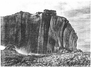
Plate I: Ice cliff at southern coast of Great Lyakhov Island, east of Wankinstan. From: E. von Toll (1895) Plate 1. The fossil auf-ice is here 15-18 m high. The vertical stripes are from the melt-water, dripping down. At the bottom of this ice-wall, two explorers are standing. This auf-ice arose right after the global Flood of Noah’s days, in 2370 B.C.E., when the Far North became very cold.
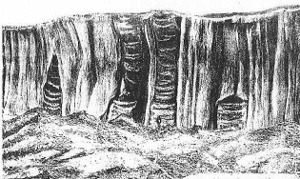
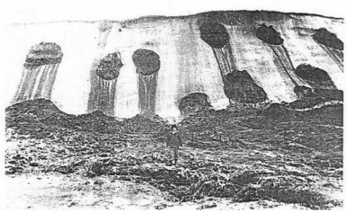
Plate II: Ice cliff at southern coast of Great Lyakhov, east of Wankinstan. From: E. von Toll (1895) Plate 2. The vertical cylindrical holes in the old auf-ice are going down right to the bottom. They are filled with alternate horizontal layers of clear ice and silt, mud, deeply frozen. The ice has closed the left and right vertical hole, before it was filled to the top. In front of the middle pillar, an explorer is standing. The heaps of mud in front of the ice-wall is, what has remained from the vertical layers of clear ice and mud in the ice-holes. When the ice had melted back, the frozen pillars of mud collapsed and melted.
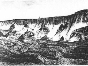
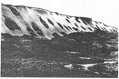
Plate III: Ice cliff at southern coast of Great Lyakhov Island, east of Wankinstan. From: E. von Toll (1895) Plate 3. The ice in the front has melted away. Only the huge “mole-hills” have remained: the silt, filling the vertical holes in the ice. They have filled out at first the large vertical holes in the auf-ice, with their alternating thin layers of clear ice and loam. In this steep cliff of old auf-ice there are several vertical round holes. Some of them have thawed away partly. Do note, please, the two explorers in the picture. The one is standing on top the old ice-cliff (in the middle of the picture). And the other one is standing on top of one of these “mole-hills”, in front of the ice-cliff. In these vertical holes in the ice, they also find isolated bones, parts of frozen bodies and whole frozen bodes of animals, which have lived up there together with the mammoth, when the climate was still mild.
In them they also find the tusks and whole frozen bodes of woolly mammoths. How have they gotten into these large vertical holes in the ice, about 3 meters in diameter? When it had become warmer, the thawed mud was flowing from the slopes of the mountains into the valley, like a large stream of lava. And in this stream of mud there were also the bodies of the mammoth-world, which had perished during the global Flood of Noah’s days. In summer, when the melt- and rain-water was flowing over the ice, it also carried the isolated bones and whole carcasses over the ice into these holes. Water and mud then filled these holes completely, usually up to its upper rim.
Plates I, II, III
The southern coast of Great Lyakhov Island, on three photographic plates
The southern coast of Great Lyakhov Island, on three photographic plates: What do they show us? What do they tell us about this fossil ice or "stone-ice", as von Toll calls it, about its origin?
Eduard von Toll: "Shown here is in the same order I, II, III, from East to West, in one row, the steep bank of the southern coast of Lyakhov Island, east of Wankin-Stan, at the mouth of the Wankina River. Let us look first at the plates I and II. The ice-wall is here about 50-60 feet (15-18 m) high. It falls down vertically. Its upper part is hanging over. The vertical stripes on the ice walls have arisen during thawing, from the water dripping down. In this way, also the parallel furrows, seen especially clear on Plate II, have arisen.
"On Plate II, in the middle of the picture, we see two darker spots, going through the whole thickness of the ice. That is the depressions, described above, of the upper horizon. Above it there lies a ca. 2´ (61 cm) thick layer of peat. In some places, the thin layer of vegetation is lying directly on the frozen ice and loam. On it, the 70 different flowing plant species, which Dr. Bunge has gathered, are able to grow now.
"These two stripes, standing in the middle of this wall, are standing so closely together that only a 2-3 feet (61-91 cm) wide mass of ice is separating them. The composition of these stripes of horizontal layers of ice and loam can be clearly seen, because when looking closely at the picture, one often sees gaps between the layers. These gaps arose, when the lighter layers of ice are melting faster, than the darker layers of loam. At the right hand of the two middle stripes, we see a similar one. It is starting at the bottom of the wall, but does not come up all the way to its surface: It is enclosed on all sides by ice, just like the one seen at the left hand of the middle stripe.
"Plate III shows us, how the stone-ice profile is melting down and how it is changed. We do see here, how the ice-wall is moving back in a half-circle into the land. The ice-wall, which first stood vertically at the seashore, is forming now the background of the front part of the island. On it, rows of cone- and pyramid-shaped hills are rising up – the layered masses of ice, which have filled the cracks of the ice, (= vertical holes in the ice) which have kept on standing, while the ice around them was melting away. The foreground shows the layers of the upper horizon, which have fallen down, because they lost their balance, and the masses of loam, which have flowed down, which are now frozen again. It looks like a field of cooled-off lava.
Erich von Toll: "These pictures are speaking a clearer language, than every description. They do show us, that the ice is undoubtedly the older formation, and that the profiles, differing from the ice as darker stripes, must have arisen later on. How can we explain now with this the conditions, which seem to contradict this, as seen on Plate II, that above the younger formation, the older one is lying: namely the stripes, left and right in the picture, filled with loam? They are enclosed on all sides by ice. We may imagine the history of these quaternary formations, with its different stages, like this:
"During the first stage, there has been a layer of ice, obviously covering the whole island, except the four mountains. How thick this mass of ice has been, we do not know, since its bottom has nowhere been observed. But its visible thickness varies between 20-70´ (6-21 m). This ice surface was obviously torn apart and was fissured, and had many narrow crevasses, cutting through the whole thickness of the visible layer.
"During the second stage, these crevasses and channels were slowly filled, layer by layer, with thin ice, loam and sand. Or the crevasses (= vertical holes in the ice) closed up again, when they had been partly filled with loam and ice. Only in this way, we are able to explain the conditions on Plate II logically. When this had happened, the next stage occurred. Now the sediments of dried-up lakes, with the remains of its fauna, covering sometimes also the ice, were laid down. Or swamps were forming on top of the watertight soil above the ice, whose water had gradually flowed there. Or loam was carried there by the wind, which later on froze. On top of the peat of the swamps, then finally, loam and sand were washed. Then, the present vegetation began to grow." - Toll, E. (1895:58, 59).
Result
This fossil ice is not made up of large ice-wedges, as some have falsely claimed. The ice has been there first. It is old auf-ice. Auf-ice arises, when the water of a river in winter is flowing on top of the ice. Layer after layer, flowing on the ice, then freezes. It fills the whole valley with ice. Then the melt-water has washed large vertical holes into this auf-ice. And the water, flowing on top of the ice, was flowing then into these holes. When this water was muddy, it laid a thin layer of loam onto the bottom of this vertical hole. When the water was clear, it lead a thin layer of clear ice onto the bottom of this vertical hole. This went on, until the hole was filled right to the top. These vertical pillars of layered ice and loam are sitting in the thick layer of old auf-ice, like a tin-can. Large ice-wedges have also grown there. But that is something different. We must keep this clearly apart.
Ice cliffs of Kotzebue Sound, western Alaska, at the Bering Strait. From: R. D. Guthrie, Frozen Fauna of the Mammoth Steppe (1990:XI). The front of the old ice has broken off here, and has slid down toward the sea shore. This fossil ice is covered by a layer of frozen silt. And in this frozen silt (not in the ice itself) they found the remains of the woolly mammoth and other kinds of animals of the mammoth fauna. There they also recovered many well preserved mammoth tusks. At the shore (in the front left) the explorers have piled up the mammoth tusks and bones, which they have found there.
Formation of ice edomas of northern Yakutia (shore of Dmitriya Lapteva Straits). Photo by S. V. Tomirdiaro. After: S. V. Tomirdiaro (1984:142) Fig. 15.1. That is ancient auf-ice. In this layer of ice, there are vertical holes, filled with alternating layers of clear ice and mud. An explorer is standing on heaps of mud, the remains of the vertical columns. When the ice melted back, the vertical columns remained behind and finally collapsed and melted.
A layer of fossil ice at the Dmitri Laptev Strait, at the coast of northern Yakutia. After: S. V. Tomirdiaro (1996:59). The ice-cliffs are 25 m high. On top of the ice is a thin layer of tundra, protecting the ice in summer from melting. Within this layer of old ice, vertical columns of alternating thin layers of frozen loam and clear ice are sitting, like in a tin-can. This ice has covered once most of the continental shelf, spreading out some 400 km further north.
This fossil ice has arisen shortly after the global Flood of Noah’s days, in 2370 B.C.E., according to Bible chronology. Suddenly, the Far North was hit by deep arctic cold, much colder, than it is now up there. The rivers of Northeast Siberia, like the Lena, Yana, Indigirka, and Kolyma, flowing northward, then froze down in winter right to the bottom. Their water was flowing then – in summer and winter – on top of the ice, freezing over in winter. Within a few years, the valleys and coastal deltas were filled with auf-ice, 20 – 50 m thick. Later on, crevasses appeared in the layer of ice. Into these crevasses, the melt-water was flowing in summer, cutting large vertical holes into them. Then they filled these vertical holes with thin alternating layers of clear ice and mud or loam. Sometimes, the melt-water also swept a whole frozen body of a woolly mammoth into one of these vertical holes in this layer of auf-ice. – First the layer of auf-ice arose, then the vertical holes in them, and then the alternating thin layers of clear ice and of mud in them. This has nothing to do with ice-wedges.
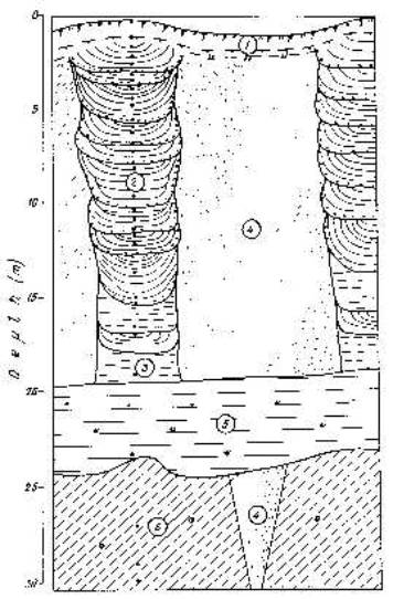
Layer of fossil auf-ice, with vertical holes in it, at the Oyagosskiy Yar exposure, northern Yakutia, south of Siberian Islands. From: S. V. Tomirdiaro (1984:143) Fig. 15.2. What does that mean? How did it arise? - Let us start chronologically, from the bottom upward: The following numbers refer to the numbers in the drawing. 6: First, at the bottom, there were marine sediments. 4: In these marine sediments an ice wedge grew, over 5 meters tall. 5: Talus (gravel, rubble, angular stones) then covered the marine sediments about 4 meters deep. 4: Then a layer of auf-ice covered this layer of talus. This layer of fossil ice was at least 20 meters deep. Crevasses appeared in the layer of auf-ice, at least 20 meters deep. Into these cracks in the ice, the melt-water was flowing in summer. They cut large, round, vertical holes into this layer of ice, at least 20 meters thick.
3: At first only clear water was flowing into these vertical holes. This are bands of very fine, conformable, interrupted ice layers. They filled the bottom of the vertical hole in the auf-ice to a depth of about 2 meters. 2: Further up, right to the top of the ice, we then find this: Bands of non-conformable ice and ice-earth intercalations in earth columns. Delineated by an interlayer of heavily peat-laden loam. These alternating layers of clear ice, mud and peat then fill the vertical hole in the auf-ice to a depth of about 18 meters, right to the top of the ice. 1: A layer of soil covers the surface of the 20 meters thick layer of auf-ice. This present tundra-soil has there a depth from a few inches to about half a meter. We should realize here: In summer, the surface of the old layer of auf-ice is melting each summer a little bit, because the layer of the tundra-soil, covering it, is not were thick. So this layer of auf-ice must have been at first much thicker than 20 meters.